
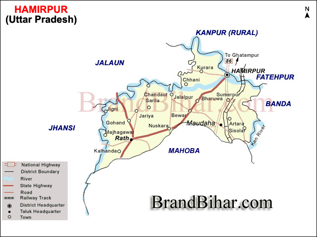
Hamirpur district lies between Lattitude 2507'N & 260 7' N. and Longitude 79017'E & 80021'E including Mahoba district. Hamirpur is bounded by districts Jalaun (Orai), Kanpur and Fatehpur in north, Banda in east, Mahoba in south and Districts of Jhansi and Jalaun on the West.
No earthquake has been observed in the district during last 200 years. The district has, however experienced on a few occasions earthquakes originating in the Himalayan boundary fault zone., Moradabad fault and Narmada Tapti fault zones.
The Climate of the district is characterised by an intensely hot summer, a pleasant cold season . The summer season from March to about middle of June is followed by the south-west monsoon season from mid-June to the end of September. October and first half of November consititute the post-monsoon period. The cold season is from mid-November to February.
May and the begining of June are generally the hottest period of the year and maximum temperature in May is about 43º C and minimum about 28ºC. The heat during the summer is intense.The maximum temperature on individual days sometimes reaches 45ºC or more. During Cold season minimum temperature sometimes drops down to about 2 or 3ºC.
Agriculture of Hamirpur, Uttar Pradesh
Land and Soil of Hamirpur, Uttar Pradesh
The soils consist of the well known bundelkhand varieties, Mar, Kabar, Parua and Rakar. Mar is often called black cottor soil. Its varies greatly in colour. It contains small lumps of kankar. Kabar range from a rich dark black to light brown. Its chief characteristics is its extreme adhesiveness, which causes it to quickly dry and cake in to hard blocks. Parua is a light coloured sandy soil, found in many forms. It is usually less rich in organic matter, but its finer texture makes it more responsive to manure and irrigation. Raker is refuse soil which occurs on sloping ground, where the action of water has tended to denude the earth of all its better qualities.
Only 27.7% land are irrigated land in hamirpur. The distribution of area of land irrigated by different sources of irrigation are as under. Canals are the main source of irrigation and are constructed by the different rivers like Yamuna, Betwa, Dashan, Barma, Ken, Chandrawal and Pandwaha.
Hamirpur is situated on the National Highway 86 (NH 86) which is also called the Kanpur-Hamirpur-Sagar road. Kanpur is 67 km, Orai 85 km, Banda 95, Rath 76 km., Mahoba 85 km, but due to bad road conditions these distances can not be covered in less than 2 hours if travelling by roadways bus. Hamirpur is well connected to the outside world. No railway station is at Hamirpur Town. The nearest railway station is Hamirpur Road which is around 5–6 km from the city lacks conveyance and falls in Kanpur district. Other nearer railway station is Bharuwa Sumerpur which is 15 km from Hamirpur.
Languages
Tongues spoken in Hamirpur include Bundeli, which has a lexical similarity of 72-91% with Hindi (compared to 60% for German and English) and is spoken by about 7 800 000 people in Bundelkhand
There are many places in Hamirpur district which have historical, cultural and religious importance. Some of them are as under :
Gram Khandey Temple - There is a very beautiful Temple in Gram Khandey.
On the eve of the outbreak of 1857, the district was in the charge of T.K. Lloyd; while in the Civil Lines the military force consisted of a detachment of the 56th Native Infantry whose headquarters were at Kanpur.
Early in June, 1857 the villagers of Ramari manifested a yearning for freedom before the actual struggle of the outbreak on the 13th of June 1857. On that day the guard at the treasury revolted and made for the house of the collector, while some freedom fighters released the prisoners at the jail. The Europeans who could, escaped while others were killed. Lloyd (collector) and Grant (joint magistrate) hid themselves in some caster-oil fields and swam down with the current of the river to the junction of the Betwa and the Yamuna, 5 km. below the town of Hamirpur. Alhirs discovered Loyd's place of concealment and reported it to the freedom fighters who captured Llyod and Grant and escorted them back to the cutcherry compound, where they were shot.
Due to contribution of freedom fighters, Hamirpur had proud of being of independent during 13th June 1857 to 24th may 1858.
On the occasion of celebration of Silver Jubilee year of Independence in 1973, 323 persons of district, who had taken part in India's freedom struggle were granted tamra patras placing on record the part played by them in the country�s freedom struggle.
There are three harvests, the autumn or Kharif have usually known as siyari, and the spring or Rabi as Unhari. The Ziad or extra harvest is insignificabt in this area. Gram, Wheat, Barley, Peas, Arhar and Masoor are the main crops of Rabi. Jwar, Rice, Bajra, Urd, Moong and Moth are the main crops of Kharif. Melon, water-melon, bitter guard, pumpkin are the main crops of Zaid
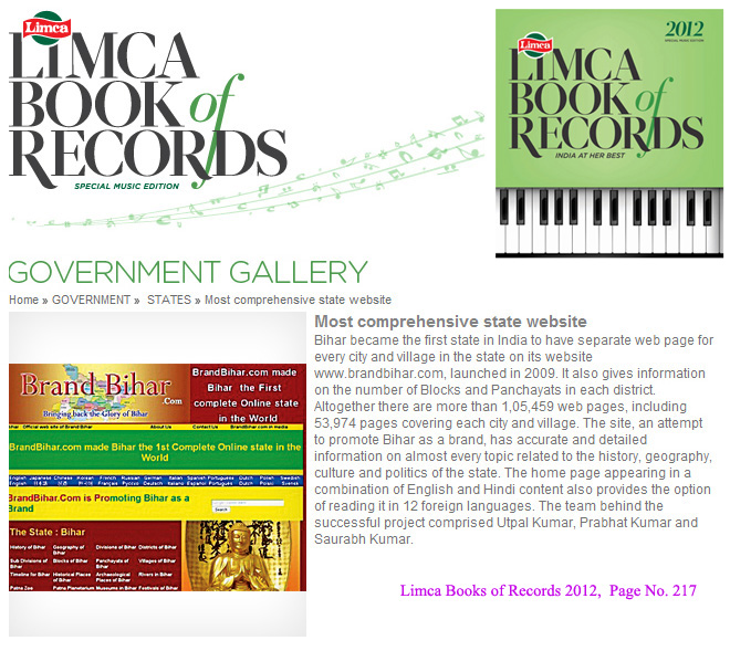
Bihar became the first state in India to have separate web page for every city and village in the state on its website www.brandbihar.com (Now www.brandbharat.com)
See the record in Limca Book of Records 2012 on Page No. 217