
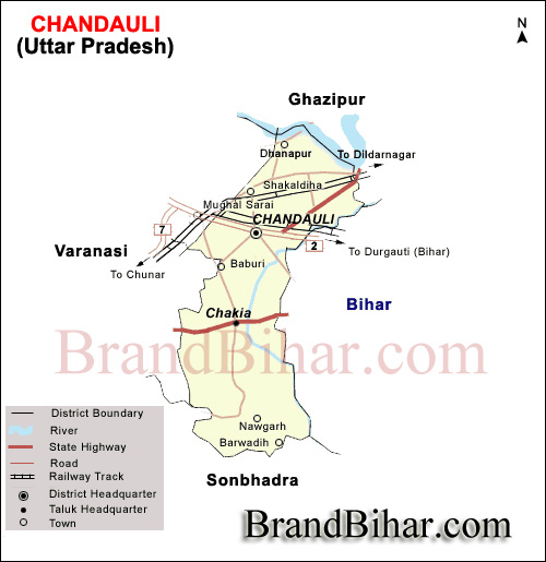
The District Chandauli is located in 24° 56' to 25° 35' to north and 81° 14' to84° 24' east at a distance of about 30 kms east-south-east of Varanasi. Chandauli is bounded on east by Bihar State , on the north-north-east of Ghazipur District, South of Sonebhadra District, South-east of Bihar and South-West Mirzapur. Karmanasa river is the dividing line from Bihar State. Ganga, Karmanasa and Chandraprabha rivers form the geographical and economic strategy of the district.
Physiography of Chandauli District
On the basis of geology, soils, topology, climate and natural vegetation the district is
subdivided in the following regions:
1. Chakia Plateau
2. Chandauli Plain
3. Ganga Khadar
Chakia Plateau -
The region is comprised of southern part of Chakia tahsil. The 100 meter contour separates the region from Chandauli Plain. It is hilly tract with dissected surface. There is a zone of scarpment in the center part which is further converted into spur towards north. The Vindhyan Range extends upto this region. The maximum height is represented by 300 m (1000’) contour which runs in the south eastern part. Variation in surface height is more in central part where as southern part is a flat table land. The general slope pattern are also found. The height decreases towards north. The rivers originate from south and drains towards north through sharp bends and lofty waterfalls. Deodari waterfall on Chandraprabha is a beautiful picnic spot. In the northern part of this zone, soil erosion along the river course is common physical feature. Bhainsora reservoir on a rivulet of Karamanasha has been constructed for irrigation and power generation. Since it is a hilly tract large part of the region is covered with forest and the area left for agricultural pursuit is very much restricted. The northern part nearby to Chakia is relatively plain and irrigated by canals. This small patch is suitable for agriculture. Paddy is the main crop which is cultivated here. Geologically the region belongs to upper protorozoic period.
Chandauli Plain
The region comprises parts of Chandauli, Sakaldiha and Chakia Tahsil. The area under Chandauli tahsil is comparatively low which causes water logging during rainy season. Surface is plain least physically variation. Major part of the region is devoid of streams. The Chandraprabha and the Karamanasha rivers drain towards north east direction through the southern part .Garai is a small rivulet of Chandraprabha .Soil erosion along the drainage course of the above rivers are an important physical feature. The general slope is towards north but there are variations at local level. The central part is relatively higher, Geologically the region is composed of Alluvium and dun gravels. The presences of large number of canals indicate its agricultural prosperity. The level surface, alluvial soil further provide impetus to agricultural pursuits. The physical conditions or suitable for the development of transport but the Ganga is a barrier in this aspect. The links with other areas are well developed.
Ganga khaddar -
It is narrow belt along the Ganga river extending from one end of the district to the other end. Surface is low lying and subject to inundation during flood. Approach of flood water delimits the boundary of this region. The Ganga is main river which flows in the northern and western part. Natural levee, dead arms of the river and sand bars the name physical features along the Gangariver. Geologically the region is composed of alluvium and dun gravels or recent period. Agriculture is limited to Rabi crops only. However thin layer of new alluvium increase the agricultural productivity.
Chandauli District Administration
District administration comprises of Revenue, Police (Law and Order), Judiciary, and Local self-government. District Magistrate is in–charge of revenue administration. He is assisted by Additional District Magistrate, Finance and Revenue) i.e., ADM (F&R). At the tahsil level Sub Divisional Magistrate is in-charge, who is now re-designated as Up-Jila Adhikari. He is assisted by Tahsildars in each tahsil and for revenue collection each tahsil is further entrusted to Naib Tahsildars and Kanongos circles respectively. For each revenue village, Lekhpal is in charge. Chief Development officer and District Development Officer are in –charge for development activities in the district. Various departments have departmental officers at the district level e.g. for Health, Panchayat Raj, Electricity, Transport, Irrigation, Jal Nigam, Animal Husbandry, Harijan and Samaj Kalyan, Agriculture, Horticulture, PWD ,etc. each have a departmental at district level office, departments point of view the district is divided into community development block. At Community Development Block level are Block Development Officers (BDO) looks after development work at community development block level. Assistant Development Officer and village Development Officers at village level.
Transportation of Chandauli District -
Chandauli is well connected by rail and road links. The services of both northern and eastern railways are available in the district. Mughalsarai junction is hardly 15 km. from the district headquarters. Mughalsarai has the biggest railway yard in India and in fact a terminating point of railways to the different directions in the country. There are 14 Railway stations linked by 101 km. long broad gauge, railway tracks within the district. Rail facilities are available to different places and directions of country from the Mughalsarai railway junction for the passengers. Regarding road transportation in the district 1206 km long metalled road are available, there are 36 km. long national highways, whereas state highway are 42 km. long. G.T road also passes through the district. Main district road covers 89 km and other district and rural road covers 559 km, whereas out of total length of 578 km long, road is managed by local bodies (49 km) and forest. 726 km road are built and maintained by P.W.D govt. and private bus services are available for both urban and rural areas in the district.
Tourism of Chandauli District
The district Chandauli is of much importance for tourism. If you visit the region of Chakiya and Naugrarh during rainy season, you will find the real beauty is gifted by the nature, whole region of Chakiya, spread over with paddy crops and cloudy sky is bending upon as if trying to touch the earth. The forest of Naugarh, beautiful Dams and waterfall always attract tourists. Naugarh, the legendary of Novel of Devkinandan Khatri, the writer of famous novel Chandrakanta In the district Latifshah Beer, Rajdari and Deodari waterfalls Chakiya, Chandraprabha dam, Naugarh Dam, Arvatand waterfall Naugarh, are the major tourist attractions. The regions bear tremendous possibility for development of tourism, specifically eco-tourism and forestry. Baba Jageshwar Nath(Hetimpur) Van Chetna Kendra, Chandraprabha Wildlife Sanctuary are being developed by Kashi Wildlife Division, Ramnagar Varanasi. Chandraprabha Wildlife Sanctuary was setup during 1957 covering 9.6 th.hectare of reservered forest area in Chandraprabha and Jaimohini Range (partially). Rajdari, Devdari and Aurwatand(Small Devdari) are the main tourist places in this range. The waterfall of Rajdari and Devdari is situated on Chandraprabha river and near to these waterfall is Chandraprabha Dam. Around the waterfall, the forest area is full of natural beauty.
Waterfall is baricated with stone wall to safeguard wild animals . specially during rainy season from July to November the beauty of the place is on peak, apprx.1 to 1.5 lacs tourists visit to the place every year.
The attractions and major spots are Dhanapur Martyr Memorial Baba Kinaram Sacred Place Chakiya Kali Mandir , Baba Latifshah Tomb and Others.
70km from Varanasi are the forest of Chandraprabha. These forests nestle within them the Rajdari and Devodari waterfalls A beautiful secluded place for a relaxed outing or a picnic. Waterfalls :1.Rajdari 2.Devdari 3.Aurvatard 4.Karmasha Waterfall and others -
Lakes :
1.Chandraprabha 2.Bhaisoda 3.Naugarh 4.Mushakhard 5.Latifshah and others
Rivers :
1.Ganga 2.Karmanasha 3.Chandraprabha and others
Dams :
1.Naugarh 2.Mushakhard 3.Chandraprabha 4.Latifshah 5.Bhaisoda
Canals :
1Chandraprabha 2.Mushakhad 3.Narayanpur Lift Canal.
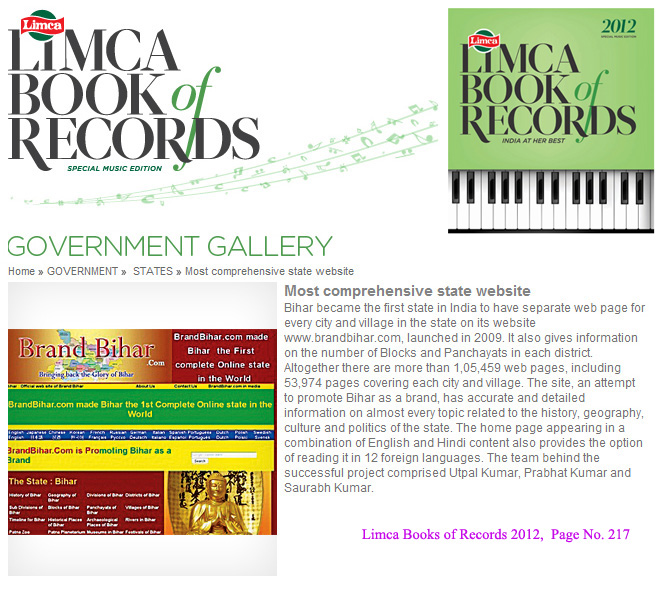
Bihar became the first state in India to have separate web page for every city and village in the state on its website www.brandbihar.com (Now www.brandbharat.com)
See the record in Limca Book of Records 2012 on Page No. 217