
The present Bhojpur came into existence in 1992. Earlier this district was part of old Sahabad district. In the year 1972 Sahabad district was bifurcated in two parts namely Bhojpur and Rohtas. Buxar was a subdivision of old Bhojpur district. In 1992, Buxar became a separate district and rest of Bhojpur district has now three sub-divisions - Ara Sadar,Jagdishpur and Piro. Ara town is the headquarters of the district and also its principal town.

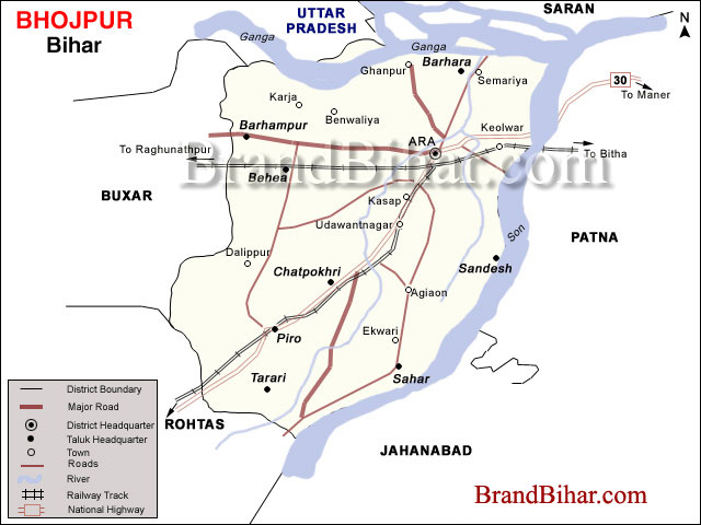
Click on the Map of Bhojpur to see the large View of Bhojpur Map
Bhojpur is located at a Longitude of 83º-45' to 84º-45' East and the latitude is 25º-10' to 25º-40' North.
>Height from Sea - The Bhojpur district is situated at height of 192.989 meters from Sea.
Area Bhojpur occupies a total of 2474 sq. kms.
Rivers are Ganga and Sone
Perinniel Rivers are Kumhari, Cher, Banas, Gangi.
Total Cultivated Area (2001-2002) (All four seasons) = 241926 Hect.
Net Cultivated Area (2001-2002) = 177275 Hect.
Net Irrigated Area (2001-2002) = 126830 Hect.
Main Crops = Rice, Wheat, Macca, Gram.
Rainfall
Normal = 913.4 mm
Actual = 1160.6 mm
Population - As Per 2001 Census
Total population = 2233415
Male population = 1175333
Female population = 1058082
Sex Ratio in Bhojpur
There are approximately 900 female for 1000 male.
Literacy in Bhojpur
Literacy Rate Total = 59.71 ( without 0 - 6 age group )
Male = 74.78
Female = 42.81
NATURAL DIVISIONS
The new Bhojpur districts consists of three sub-divisions, viz., Ara Sadar; Jagdishpur and Piro comprising 14 development blocks stretching over an area of 2,37,526 hectors. The entire strip of land between the river Ganga on the north and the main line of Eastern Railway on the south is low laying deposits of silt from the Ganges almost every year and is extremely fertile. In fact, this region is considered to be the best wheat-growing area in the state of Bihar .
The district has rivers running almost three sides-North, East, and some part of Southern boundary. The Ganges forms the northern boundary of the district. The low-lying rich alluvial plains in the north-eastern and owe their fertility to the river Ganges . The rivers Chher and Banas fall into the Ganges .
The Sone is another important river in the district. The Sone enters the state of Bihar at the tri-junction of Palamu (Jharkhand), Mirzapur (U.P.) and Rohtas( Bihar ). It runs along the southern and eastern boundaries of the district of Bhojpur until it merges in the river Ganges near Maner in Patna district.
According to the District Statistical Report. There 1244 villages in the district out of which 251 are non-residential and 993 residential. There are 228 Panchayats and 12 revenue circles, 6 Town areas, 22 Police Stations, 5 Sub-Police Stations, 1 Railway Police Station, 7 Out-Post-Police Stations in this district, This report also provides the information about Post and Telegraph, which is as follows :
In this district, there is one G.P.O. situated at the district headquarters Ara. There are also 41 Sub-Post Offices, 3 Addl, Departmental Post Offices, 252 Addl. Departmental Sub-Post Offices. Altogether 989 villages are covered by these Post Offices. The number of Telegraph Centers in 35 in the district of Bhojpur.
CLIMATIC CONDITIONS
The climate of the district is of moderately extreme type. The hot weather begins about the middle of March, when hot westerly winds begin to blow during the day. The months of April and May are extremely hot. In a normal year, the monsoon sets in by the third week of June and the rains continue with intermissions till about the end of September or the early part of October. The cold weather begins from the month of November and lasts till the beginning of March January is the coldest month when temperature comes down as low as 10 degree centigrade. From the month of April till the first break down of the monsoon, the district experiences occasional thunder-storms also.
RAIN FALL
Rains set in June accompanied by a fall in temperature and increase in humidity. The district experiences maximum rains during the months of July and August. The average rain-fall, in the normal conditions, recorded in these months is in the proximity of 300 mm. The district gets easterly winds from June to September, which brings rains, From October the direction of the winds is reversed and westerly winds blow till May. There is slight rainfall in October, but November and December are quite dry. Some winter rain occurs in January and February.
IRRIGATIONAL FACILITIES
The river Sone and Ganges are the perennial sources of surface water. They can provide irrigation to major portion of agricultural lands. In the "Pre-Zamindari Abolition" days the Zamindars used to maintain "Ahars" and Pynes" which served the purposes of both irrigation and drainage in certain pockets of the district. Ordinary wells also used to be a good source of irrigation.
The District Statistical Report published by the District Administration in the 2001, 15,493 hectors, and land is irrigated by big Sone canals, 14,940 hector, land is irrigated by middle Sone canals and 18,379 hectors, and land is irrigated by small canals. 2,582 hectors, land is irrigated by Govt. Electronic Tube wells and 2,099 hectors, of land is irrigated by Govt. Tub wells operated by diesel. The area of land irrigated by private Electric Tube wells is 8,263 hectors. And 16999 hectors of land is irrigated by diesel operated private Tube wells 58,586 hectors of land irrigated by other sources or irrigation like Ahars, wells and ponds etc. Thus this statistics shows that 1, 77,341 hectors of land out of 2,37,526 hectors of land of total area is irrigated . It means 74.66 % land of the district is irrigated.
LAND USE PATTERN
In this district both the irrigated and un-irrigated areas except the small hills are being exploited for cultivation. Even some of the large ponds and "Jhils" which were duck-shooting areas have been de-watered and put to crop and grows "Boro crops". Intensive agriculture is also being attempted by what is popularly known as "Package Program". The Block Development Authorities are also trying to extend cultivation and improve the output. The remodeled Sone Canal System has the objective of bringing in more land under cultivation. Horticulture is spreading and orchards are springing up of all parts.
The District Statistical Report published by the District Administration of Bhojpur in the year of 2001 shows the area of different crops production i.e. Paddy-1,05,155 hectors, Wheat-67,259 hectors, Maize- 2,779 hectors, Barley-1,154 hectors Gram-5,017 hectors Peas-2,016 hectors, Arhar-919 hectors Masur-8,115 hectors Khesari-8,989 hectors Oil seeds (Sarso) 2,866 hectors Spices 31 hectors Vegetables 5,119 hectors, Fruits 2,651 hectors and Sugar cane 209 hectors.
This report also published the data of the rate of production, which is provided to the district administration by the State Directorate. It states the rate of production different crops per hectors as follows:
"Paddy (High yielding irrigated)-3502 Kg. per hectors. Paddy (Locally irrigated) -3330 Kg per hectors, Wheat (High yielding irrigated)-2725 Kg per hectors. Wheat (High yielding un-irrigated)-2707 Kg. per hectors Masur-1047 Kg. per hectors Khesari-986 Kg. Per hectors. Oil seeds (Sarso) 679 Kg. per hectors and Gram 937 Kg. per hectors.
MINES AND MINERALS
Mines and minerals resources in new Bhojpur district are very little. The only mineral product in this district is the sand from Sone river. About 40 Kms. length of Sone river forms the part of southern and eastern and eastern boundary of the district of Bhojpur. The only managed sand - collecting centre is Koilwar, which is about 5 Kms. strips. About 35 Kms length is not properly managed to gather the sand.
INDUSTRIALIZATION
After bifurcation of the old Shahabad district in the new district of Bhojpur and Rohtas the large scale industries generally fell in Rohtas district. There are, however, different types of small & cottage industries other than some agro-based industries located in the district of Bhojpur.
The District Statistical Report shows that between Apr-1992 and Aug-2000, 1085 small tiny and cottage industries were registered with the District Industry Centre, Bhojpur. Altogether the capital invested in these industries is Rs-869.19 Lacs. and 1858 persons are employed in these industries. There is an industrial area located at Gidha (Koilwar) spread in an area of 30-40 acres of land under the Patna Industrial Development Authority. A bottling plant of Indane Gas (LPG) is also started in this area. The development of industries depends on the regular supply of power but the district gets very short supply of the electricity against the required energy. The industrialization of the district badly hampered due to this problem.
Sun Temple at Dev :
The Dev village of Tarari block has statue of the SUN GOD besides several other deities. These statues are said to be of 14 th century or even before.
Veer Kunwar Singh Kila , Jagdishpur
The great warrior of 1857 belonged to Jagdishpur. His fort is still there to reminds us of the great son of the soil who fought for the freedom till his last.
Maharaja College, Ara
The present Maharaja college premises is an important historical site. There is an entry point of a tunnel that is believed to be connected with the Jagdishpur fort of Kunwar Singh.
Shahi Masjid :
This five Gumbad mosque, the second of its kind in India was constructed by Shahjahan in 1623 AD. This is situated near Aranya Devi temple.
Karbala, Mosque of Maulabagh :
This mosque was built around 1817 with Aurangjeb's assistance. It is situated at Maula Bagh muhalla at Ara.
Aranya Devi Temple
This is famous temple of Aranya Devi ( Forest Goddess ). She is said to be the deity goddess of Ara town . Here one statue is of ADI SAKTI and the second is established by the PANDAVAs . The temple is very old and draws many devotees every day. It is situated at the top of stone boulders.
Chaturvuj Narayan Mandir
This very ancient statue of Laxmi -Narayan is situated at Chaturvuj village of Piro block.
Bhavani Mandir
Chaturvuj Baraon - 13th century statue .
Jagdamba Mandir
Here is an ancient statue of Goddess Jagdamba at Mukundpur village of Charpokhari block.
Parswanath Mandir
It is a century old Jain Temple located at Masadh Village.
Mahamaya Mandir
This temple is at Ekwari village of Sahar block. This was made during Mughal period.
Mahathin Mai Mandir
This is located at Bihiya, draws lots of women devotees.
Jain Sidhant Bhawan
It has a such library which contains unique collection of materials related to Jainism.
Paihari Jee Ka Ashram
It is an ashram at Dhrampur village at Sahar block.
Lakar Sah Ki Mazar
It is situated at Sahpur, it a famous mazar of a local muslim saint.
Kurwa Shiv
There are some ancient statues related to Banasur. It is situated in Shahpur - Billoti Road.
Venkatesh Mandir
This temple situated at Perhap village has a statue of Southern architectural style.
Sahi Jama Masjid
This mosque built by Shersah is located at Garhani Bazzar. Renovation work is in progress here.
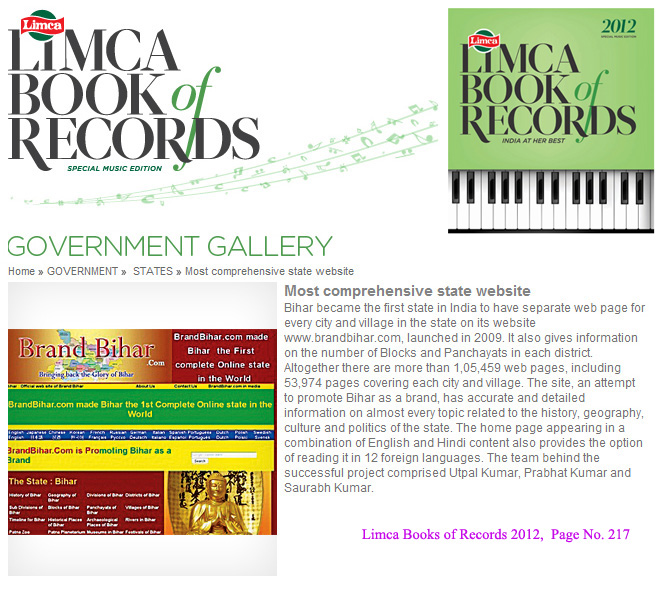
Bihar became the first state in India to have separate web page for every city and village in the state on its website www.brandbihar.com (Now www.brandbharat.com)
See the record in Limca Book of Records 2012 on Page No. 217