
Balrampur is a city and a municipal board in Balrampur district in the state of Uttar Pradesh, India. It is situated on the bank of river Rapti and is the district headquarters of Balarampur district. The creation of Balrampur District was done by G.D.No. 1428/1-5/97/172/85-R-5 Lucknow dated May 25, 1997 by the division of District Gonda. Siddharth Nagar, Shrawasti, Gonda District, are situated in the east-west and south sides respectively and Nepal State are Situated in its northern side. The area of the district is 336917 Hec. In which the agriculture irrigated area is 221432 Hec. In the north of the district is situated the Shivalics ranges of the Himalyas which is called Tarai Region.
The territory which the present Balrampur district covers was a part of the ancient Kosala kingdom.
Sravasti was the capital of Uttara (North) Kosala. The ruins of Sahet, ancient Sravasti, spread over an area of 400 acres (1.6 km2). Towards the Rapti River, a little north of Sahet, lies the ancient city of Mahet. The fortified entrance to Mahet is made of mud, constructed in a crescent shape. The Sobhnath temple houses the great Stupas. These Stupas reflect the Buddhist tradition and boast of the history of the monasteries in Balrampur.
Jeetavana monastery, one of the oldest monasteries in the country is said to be one of the favorite sites of Gautam Buddha. It contains the 12th century inscriptions. There is also a sacred tree of Peepal nearby. It is said that the tree was grown from a sapling from the original Bodhi Tree at Bodh Gaya.
Gautam Buddha spent 21 rainy season under the sacred Peepal tree. The famous incident of Angulimal happened in the forest of Sravasti, where the dacoit who used to kill people and wear a garland of their fingers, was enlightened by Gautam Buddha.
Another site of religious importance in the city is Sravasti. It is said that Mahavira Jain, the 24th Tirthankara of Jainism, 'influenced' this place. It houses the Shwetambar temple.
The area covered by the district was a part of Bahraich Sarkar of Awadh Subah during the Mughal rule. Later, it came under the control of the ruler of Awadh till its annexation in February, 1856 by the British government. British government separated Gonda from Bahraich and it became a part of Gonda.
During the British rule a commissionary was constituted for the administration of this area with its headquarters at Gonda and military command at Sakraura Colonelganj. During this period Balrampur was an Estate (Taluqdari) in Utraula tehsil of Gonda district, which consisted 3 tehsils, Gonda Sadar, Tarabganj and Utraula. After independence, Balrampur estate was merged with Utraula tehsil of Gonda district. On 1 July 1953 the tehsil of Uttraulla was bifurcated into two tehsils, Balrampur and Utraula. In 1987 three new tehsils were created from Gonda Sadar tehsil, namely, Tulsipur, Mankapur and Colonelganj. Later, in 1997 Gonda district was bifurcated into two parts and a new district, Balrampur was born consisting of three tehsils of the northern part of the erstwhile Gonda district, Balarampur, Utraula, and Tulsipur.
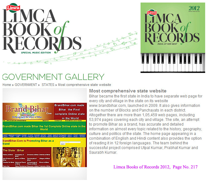
Bihar became the first state in India to have separate web page for every city and village in the state on its website www.brandbihar.com (Now www.brandbharat.com)
See the record in Limca Book of Records 2012 on Page No. 217